Hood County Texas Genealogical Society
LORE & LOVE OF COMANCHE PEAK
By Mary Kate Durham
Hood County News - January 30, 2001
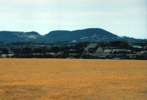
Comanche Peak - Photo by Wayne Moyers
When you are driving toward Granbury from Cresson, can you truthfully say that the first view of Comanche Peak fails to give you just a little thrill?
For many of us it means we are coming home. The longer we have been away, the more special it is.
I was interested to read in Vance Maloney's book, The Story of Comanche Peak, that the Indians sometimes referred to the Peak as the "Sleeping Lady." Look again the next time it is in your view.
One day I found a map at 'Books on the Square' that was from the Spanish explorers' time. In our area was a spot marked as "Rocky Butte." I found this interesting that we have been on the map since the 1600s.
The river was shown along with the "butte." Other names that have been found include "Loma Alto," "High Peak" or just "Peak."
Since the Comanche Indians are known to have used it, gradually their name was added; however, "Peak" is misleading. This area is a mesa and is flat on top.
Whatever it may be called, it is still my own mountain.
Along with the Peak it seems only fitting that we include its companion, the Brazos River. The Indians referred to the two in this manner. When the Brazos began to flow toward the Gulf of Mexico, it could not seem to leave the Peak. It continued to return. This caused the many bends that we have today.
The largest is what was first called "deCordova Bend"-now Pecan Plantation. The river almost flowed into itself. This formed the "narrows" and made the ideal location for deCordova Dam.
Other bends are Stockton Bend, Lietch Bend, Carmichael Bend, Mitchell Bend, Cox Bend, and Turner Bend. Some of these open into Somervell County and some into Hood.
In the early history of Texas, the Peak was used as a meeting place for government announcements. When Texas won its independence from Mexico and later in 1845 another gathering to advise everyone that Texas was now a state in the Union. Numerous meetings with the Indians regarding treaties, etc. were held. In the Hood County Museum today there is an exhibit of items believed to be left behind after one of these gatherings.
Throughout these times there had been no private owner of Comanche Peak and its land. On Aug. 25, 1847, Gov. J. Pickney Henderson granted 640 acres to John F. Torrey.
He was one of a rather large family who had come to Texas very early from Ashford, Conn. He and his brothers had been school classmates with Charlie and George Bernard. John Torrey joined the two brothers in forming their trading posts. He did not live on the Peak until 1880 when he built a double log cabin on the east slope.
Mr. Torrey died in 1893 while visiting his son in San Antonio. Mrs. Torrey did not continue to live on the Peak; however, other families did.
It has been confirmed that Luther Blackstone was hired to drill a well there in 1909. Others remember a house and windmill there in 1910. Many sightseers seemed to visit as well.
My father was in school at Add-Ran Jarvis at Thorp Spring in this time period. He did not enjoy the memories of a professor who thought it to be great fun for the students to run to Comanche Peak and return for their morning exercise.
When I would ask to visit the Peak, he would tell me he never wanted to go near it again. Many others seem to and they stayed to carve their names and dates into the rocks. These are still visible today and are very interesting to read.
The Torrey heirs sold the Peak in 1916 to Lovelace S. Ginn. The Ginn family lived on their farm where The Shores development is today. They had a beautiful view but never lived on the Peak. Their granddaughter was one of my dear friends after we started to school in 1931. When she died a few years ago, she was buried in the Cresson Cemetery.
As I stood at her grave and gazed into the distance, I was surprised to see Comanche Peak on the horizon. I thought it was meant to be.
There is a good view from the Barnard's Trading Post Historical Marker on Highway 67 east of Glen Rose. Another sighting I enjoy is just south of Weatherford on FM 51. From the west the Peak becomes the "Disappearing Mountain."
Mr. Ginn's family sold the Peak property to J. Herbert Dickey in 1947. Mr. Dickey also purchased some additional land east of the Peak and built a brick home there for his family. He truly used the land as a working ranch.
Because some of his livestock continued to crowd into the back of the caves, he had the entrances blasted and closed. It was good for him, but we lost the mystery of the caves.
When Mr. Dickey could no longer attend to the needs of the Peak, he sold it to Courts Cleveland Jr. and Joe Nutt. They continued to use the land as a ranch. They were also kind enough to allow the local Historical Society to open the area for visitors one day in the spring. We discovered we could actually take our vehicle to the top.
We found the name rocks and mostly enjoyed the view. The elevation is 1,229 feet. We could easily understand why the Indians used it for a signal base.
With the new millennium the ownership has now bee passed to Mr. Ken Hill. New happenings are in the offing. Time will tell!
~ Web Page by Virginia Hale ~
2001 HOOD COUNTY TEXAS GENEALOGICAL SOCEITY